James River Trails
The James River Park System (JRPS) Loop is a loop combining the five major downtown trails: Buttermilk, Buttermilk Heights, North Bank, Belle Isle and Forest Hill Park. Loops of the system can range between 8 and 13 miles depending on the route taken.
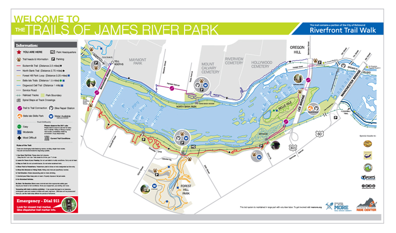
Main Trailheads
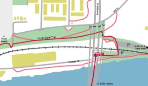
Tredegar
Considered by many to be the main parking area for the JRPS loop, the lot here fills up quickly on summer weekends (take 5th St. South to Tredegar St west to get to the lot). This is the only parking available for Belle Island so be prepared to hunt for a parking spot. Taking the suspended pedestrian bridge across the James takes you to Belle Island. Heading uphill and across the old canal takes you to the start of the North Bank Trail. The trailhead for the North Bank Trail can also be access via an access road or a staircase from Oregon Hill Parkway at Cherry St .
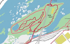
Belle Isle
Belle Isle is the most popular section of the James River Park System. On summer weekends you’ll find the island covered in people. The main trail tries to route you around the most popular pedestrian routes. It is also the home of the Belle Isle Bicycle Skills Area.
See the Belle Isle page for more information.
22nd Street
The 21st Street Trailhead off of Riverside Drive provides access to Belle Island by crossing the pedestrian bridge over the railroad tracks and the Buttermilk Trail. The 22nd St. parking lot is only open on summer weekends. The Buttermilk Trail heads west from parking lot.
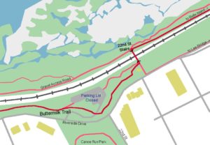
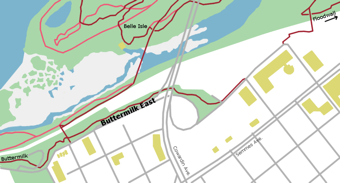
Buttermilk East heads east from the 21st St. Trailhead. It provides connections to the Floodwall, Slave Trail and Ancarrow’s East.
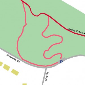
Reedy Creek
Reedy Creek is the “home” of the James River Park System. The Trail Care Crew and the JRPS Staff are based out of the Visitors Center building. A popular kayak put-in and take-out, he parking lot here is often full of hikers, dog walkers, mountain bikers and kayakers. The Buttermilk Trail crosses the parking lot entrance. Head east to 22nd St or west to the Boulevard Bridge.
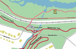
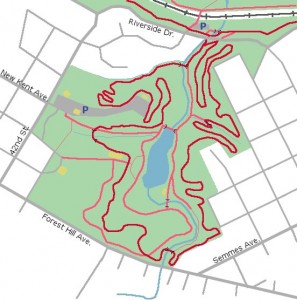
Forest Hill Park
From the Reedy Creek Trailhead, head east on the Buttermilk Trail for 100 feet to Reedy Creek and go through the tunnels to access to the Forest Hill Park trails (or head east for 200 feet on Riverside Drive). Forest Hill Park adds a 3.2 mile loop to the JRPS loop.
See the Forest Hill Park
page for more information.
42nd Street
Located just uphill from Reedy Creek at 42nd Street and Riverside Drive, this trailhead has parking for 5-6 cars. A new trail, replacing the old washed out trail, has been constructed to provide access the the Buttermilk Trail.
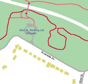
43rd Street
43rd is the end of the Buttermilk Trail and the start of Buttermilk Heights. This trailhead, used mainly by local residents due to the often closed parking lot, 43rd Street gives access to the south side rocks on the James River by crossing the pedestrian bridge over the railroad tracks and the Buttermilk and Buttermilk Heights Trails by following either of the trails downhill.
Boulevard Bridge South
There is no parking at the Boulevard South Trailhead on the west side of the Boulevard Bridge. The Buttermilk Heights Trail ends here and the JRPS loop continues on the sidewalk across the Boulevard Bridge. A side trail leads you down to the railroad tracks. The gravel road on the other side of the tracks leads you back to Reedy Creek and 22nd Street. Riverside Drive access is available on the east side of the Boulevard Bridge, but parking is very limited.
From here, it’s just a 3 mile road ride to either Powhite Park or the Pony Pastures (and beyond).

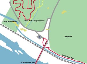
Boulevard Bridge North
If the parking lot at the base of the bridge is full (parking lot is located off of Pump House Drive), additional parking is available up the hill at the Carrillon and dog park. This is the start of the North Bank Trail – take the trail under the Boulevard Bridge. The first section of which leads you behind Maymont Park. To get to the Buttermilk Trail, take the sidewalk across the Boulevard Bridge.
From here you follow Pumphouse Drive to the west to take an 1 mile long “pump track on a hill” loop tough the trails at Dogwood Dell.
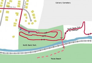
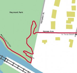
Hampton and Kansas
The trails climbs a steep hill from Maymont to reach the intersection of Hampton and Kansas. The closest parking lots are at the Boulevard Bridge North or Texas Beach. From here, the trail run west behind Maymont and heading east, it shares the road along Kansas Ave to the Texas Beach Trailhead.
Texas Beach
This neighborhood trailhead is popular with college students and dog walkers. The alternate trails provide access to the river and rocks at Texas Beach on the far side of the pedestrian bridge over the railroad tracks. The North Bank Trail runs uninterrupted to the east from here all the way to Tredegar.