Pony Pastures
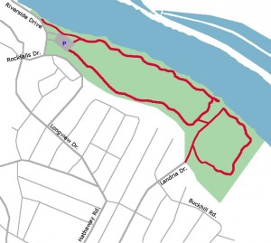
While most people go to the Pony Pastures to swim, boat or hike, they are also great place to learn how to ride your bike off-road. The main trails are wide and gravel, making them excellent for beginner off-road riders. The main loop is a over a mile long and the loop around the wetlands adds another half mile or so.
Directions:
By Car:
The main Pony Pastures parking area is located on Riverside Drive near Rockfalls Drive.
From the West, take Forest Hill Ave. to Hathaway Road. Head South on Hathaway. It will bend to the left and become Longview Drive. At the stop sign, turn right onto Rockfalls Drive, then an immediate left onto Riverside Drive. The main parking lot will the first entrance on the right.
From the East:
From Huguenot Road, exit onto Riverside Drive. Turn right (east) on Riverside Drive and follow the scenic road until you reach the Pony Pastures parking lot.
By Bike:
The Pony Pastures Wetlands Area is only 3 miles away from the JRPS and can be biked to by staying on neighborhood streets. From the Nickel Bridge South Trailhead, head south (uphill) on Westover Hills Boulevard. Turn right onto Riverside Drive. Follow Riverside Drive west under the railroad bridge. Turn right on Fairlee Rd. Turn right on Forest Hill Ave. and carefully cross the railroad tracks and the Powhite Parkway. Just after the golf course entrance, turn right on Rettig Rd. Turn left on Westchester Rd, then left on Buckhill Rd. In four blocks, turn right on Landria Rd. The Wetlands Area trailhead is located at the end of Landria Rd.
Map of Bike Route from Buttermilk Trail